Showing posts with label geography. Show all posts

22 June 2010

The Shorkneys: Getting to Orkney, Shetland, and Back

(Note: "Shorkney" is not a real word. We're just using it to write about our recent trip to Aberdeen, Orkney, and Shetland.)


Last week, Nana and I made the long trek from Edinburgh to Orkney, Shetland, and back.

It's not easy getting all the way up to 60° N, but that's part of the charm. There are regularly scheduled flights from Edinburgh and Glasgow to Kirkwall in Orkney and Lerwick in Shetland, but they cost a lot and tend to fill up fast in the summer. The more popular route involves a train or a drive and some combination of ferries, mostly operated by Northlink.

The shortest ferries run between Caithness (the northern tip of the Scottish mainland) and Orkney, crossing the very unpleasant Pentland Firth, where the North Sea and the North Atlantic meet, creating some pretty violent currents. A longer route runs overnight between Aberdeen and Shetland, stopping off in Orkney on the way.

We took the latter option, both because we were told to expect calmer seas and because Aberdeen is easier to get to than Caithness.

The ship itself (the "Hjaltland," using the Old Norse for "Shetland") was surprisingly nice. You never know what you're going to get when you hear the word "ferry," but the Hjaltland was less like a boat than it was like a small floating hotel.

When you board the Hjaltland, you enter a small lobby area, complete with an abstract sculpture of a Viking.

(With horns! Tut, tut: Vikings didn't wear horns!)

In addition to an array of cabins, the ship also had a cafeteria, a fancy sit-down restaurant, a gift shop, a "cinema" (chairs arranged around a large flat-screen), and two bars. The ship also had a misleadingly-named "sun deck," which was nevertheless a great spot for watching our departure from Aberdeen.


Our first leg of the trip took us from Aberdeen to Kirkwall in Orkney. It was an evening run, from 5pm to 11pm, so we didn't book any assigned space--we just camped out in the bar and watched the World Cup. There was a little difficulty getting from the ferry terminal to our guest house, as both Google and Lonely Planet seem to think that the Northlink ferries arrive at the small pier in the middle of town, not the larger pier on the outskirts. But Nana saved the day by hailing a bus!

Our second leg, from Kirkwall to Lerwick in Shetland, was a short overnight run. The cabins were all full by the time we booked, so we had to settle for sleeper seats in the recliner lounge.

The chairs were pretty comfy (Nana adds: So was the floor!), and certainly a whole lot better than you would get in coach on an overnight flight. But an airplane has at least one advantage over a ferry: the noise. On a plane, the jet engines drown out all the disgusting sounds people make when they sleep. On a ferry, you get to hear the symphony of farts, belches, and snores in their full glory.

The last and longest leg of our trip, from Lerwick back to Aberdeen, was also the comfiest. We were lucky to book a small twin cabin with a little window out onto the sea.

The cabin also came with a bathroom, complete with the world's smallest shower!

Bonus Fact: Did you know that you get less motion-sick if you're lying down?

Bonus Bonus Fact: After you spend a night on a ferry and then three hours on a train, you feel like the earth is shifting under your feet the following day! Whee!

12 June 2010

London Museums, Part II: Greenwich

Greenwich has a special place in my heart because of the time during 12th grade astronomy when my friend Najja noticed our textbook had accidentally spelled it "Greewinch," which then became our running joke for the rest of the year. But whatever way you spell it, Greenwich is a treat.

The National Maritime Museum has the actual uniform Nelson was wearing when shot on the quarterdeck during the Battle of Trafalgar. The bloodstains still on the uniform are dramatic, but what I found most touching were the non-regulation stockings, which sailors often wore in place of uniform goods because they were warmer. I like the idea of Britains' greatest naval hero dealing with such a plebeian concern as cold toes.

We also offer a hearty salute to the Discover Greenwich Museum, where Justin accidentally left the camera among a set of foam blocks but fortunately recovered it in time for the rest of the tour. The museum has interesting and accessible information about the town as well as the pre-naval history of the site (including Anne Boleyn's palace).

Greenwich Naval Hospital wasn't really a hospital in the modern sense - that is, a place for treating patients. It was more of a nursing home for sailors too old or injured to serve at sea anymore. It housed sailors between 1694 and the 1860s, when it was closed down, and was funded both by charitable donations and mandatory deductions from the paychecks of active sailors.

Wearing replica pensioner's garb:

Relaxing in a replica Hospital room:

(For those of you who don't think Justin is in enough pictures, that's his shadow on the bunk. That's kind of like a picture of Justin. Maybe?)

But Greenwich, England, did not earn its UNESCO World Heritage status as "Maritime Greenwich" for its museums, even though they're quite nice and spectacularly free of charge. It received it because, among other reasons,
Criterion (ii): Maritime Greenwich bears witness to European architecture at an important stage of its evolution, exemplified by the work of great architects such as Inigo Jones and Christopher Wren who, inspired by developments on the continent of Europe, each shaped the architectural development of subsequent generations...
And
Criterion (vi): Greenwich is associated with outstanding architectural and artistic achievements as well as with scientific endeavour of the highest quality through the development of navigation and astronomy at the Royal Observatory, leading to the establishment of the Greenwich Meridian and Greenwich Mean Time as world standards.
Let's tackle Criterion (ii) first.

Christopher Wren, perhaps best known as the architect of St. Paul's Cathedral, planned the Old Royal Naval College with a dedication to symmetry and under the strict mandate not to interfere with the view of the Queen's House (by Inigo Jones) to the river. In fact, the foam blocks where Justin mistakenly left the camera were there so you could experiment with the way you would have responded, architecturally, to Wren's challenge. I'm fairly sure, however, that Wren had no foam blocks and had to do it the hard way.

Wren ultimately devised this remarkable panorama, seen more clearly in the Wikipedia article here:

The Queen's House is so tiny that Justin and my combined big domes (did you know there wasn't a ski helmet in all of Japan that fit Justin's head?) completely erase it from the picture. Here it is when I relocate to the right:

I always thought my college dining halls were fairly attractive. Compare them to the Painted Hall, they're downright dull.

Those clever things in the middle are mirror tables. Having schlepped all over the world getting neck cramps trying to look at all those ceilings people spent squillions of dollars on, I heartily say, forget the architecture. These tables constitute Greenwich's greatest service to mankind. Here's the ceiling, as photographed in the table.

The man who painted them, James Thornhill, was paid by the yard and eventually knighted for his work. Who wants to volunteer to tell Michelangelo?

The Chapel of St. Peter and St. Paul is a lovely English Baroque space for both worship and music. We were lucky enough to visit during a rehearsal by some students from the Trinity College of Music, also located in Greenwich. The acoustics were lovely, as was the chance to sit down for five minutes. Traveling ain't always as glamorous as it looks.


And now on to Criterion (iv), the one about the Royal Naval Observatory. Before coming here, I knew Greenwich more as the home of Greenwich Mean Time than the home of anything else. (It also is the home of Meantime Beer, which is outstanding).

Dava Sobel's (fun and readable) book Longitude outlines Britain's search for a practical way to determine, quite literally, where on earth you were. For a pretty long time, it's been easy to calculate your distance north or south by using the stars. Unfortunately, calculating your distance east and west was not so easy. A mistake might mean that rather than being safely at sea, you were in fact six inches from crashing into Tierra del Fuego.

The solution, devised by clockmaker John Harrison in the mid-1700s, was a clock that worked at sea. If you had three pieces of information - time at your home port (as shown by the clock), the longitude of your home port (previously calculated), and the time where you were (set by noon, the sun's peak in the sky), you could then calculate your longitude mathematically. This represented a colossal breakthrough in navigation, and also in the art of crafting timepieces, since Harrison couldn't use wood (warped by humidity) or weights (rolling at sea) in his oceangoing clocks. The series of clocks he made are on display at the observatory.

The Greenwich Time Ball on top of the observatory here is raised and dropped at 1 PM every day, a holdover from Ye Olden Times as a way to signal the time to ships in the harbor (harbour!), therefore allowing them to set their clocks for navigation. Edinburgh has its own equivalent - a ball on Calton Hill and Edinburgh Castle's One o'Clock Gun, presumably because Edinburgh weather does not always allow you to see the hilltop.

I was so excited at this prospect that I dragged Justin out of the museum in the rain to take a picture.

He was not impressed, hence the lack of climactic "after shot" of the dropped ball. Alas.

The Greenwich Meridian, also known as the Prime Meridian, is the officially designated line for 0 degrees longitude, which means it divides the Western and Eastern Hemispheres. It's like the Equator but going up and down instead of around the middle. Unlike the Equator, it's completely arbitrary. The Equator is astronomically and geologically defined: it marks the location on the earth's surface when the sun is directly overhead at noon on the solstices. It also marks the spot at which every day, regardless of the season, has the same amount of daylight (on Earth, roughly 12 hours. I, by contrast, live in Scotland, where last winter's December solstice featured a soul-destroying six hours and fifty-seven minutes of daylight and the upcoming June solstice will probably be around seventeen hours and thirty-five minutes long. As I write this post, it's 10:21 PM and light enough to read a book outside. It's a weird place, Scotland.)

Anyway, unlike the equator, which has to be where it is, the Prime Meridian could be located anywhere. Beijing. Hoboken. Your house. There was, in fact, a time when other Prime Meridians were in use, most particularly the Paris Meridian by the rival French. But in 1884, when it was put to a vote, Greenwich won by a vote of 22-1. (France abstained). This is primarily due to the fact that just as Britain's navy dominated the seas, Britain's mapmakers dominated cartography, and most people had just become used to calculating their longitude from a British map using a Greenwich meridian. America's choice of Greenwich as the starting point for its domestic time zones, and therefore also for its maps, probably didn't hurt, either. Oh, France - have we always been a thorn in your side? I hope the answer is yes.

So here you have them, folks, a large part of the reason I went to Greenwich and definitely all of the reason I schlepped up the huge hill to the observatory: Photos at the Prime Meridian!

Justin doesn't know which way to go:

Our marriage looks good from the outside, but really, we're not even in the same hemisphere these days:

My brother-in-law Ryan always mocks my family for being slow, but I bet he's never run across two hemispheres in two seconds!

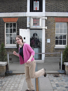
(Ryan is probably saying, "How did that take you two whole seconds?" I blame our camera's busted autofocus, which means it takes us way too long to take pictures.)

So that's Greewinch. Hope you enjoyed!

20 March 2010

The Vernal Equinox

Today is the vernal equinox, which means that everywhere in the world will get roughly the same amount of daylight today.

Since the autumnal equinox back in September, every day in Edinburgh has been shorter than we're used to, having spent most of the last 25 years between 35 and 45 degrees north. In December, the days were really short--full dark by 4:30 most days. From now, however, every day will be longer than we're used to--not by much at first, but by June it won't actually ever get fully dark.

Just another reminder of how far north we are here in Scotland: if you drew a line across the globe straight West from here, it would pass through Labrador in Canada and through the very southern part of Alaska and the Aleutian Islands.

06 March 2010

Navigating Edinburgh

Slate.com has an interesting article up about the difficulties of navigating in London. These difficulties arise from the fact that London isn't really one city--it's a bunch of medieval-era villages that over the centuries grew together into one massive, lumpy blob.

Many of the article's insights apply to Edinburgh, as well, since Scotland's capital is also made up of dozens of discrete (and unplanned, with a few exceptions, such as New Town) old neighborhoods that have grown together over the course of hundreds of years. For example: Londoners rarely refer to "blocks," which is much too regular for the odd shapes created by the city's haphazard road network, but instead navigate by prominent landmarks and major intersections.

In Edinburgh, folks do the same thing, but in many cases take it one step further by giving each little stretch of a major road an entirely new name. Our apartment, for instance, sits between two main routes into Old Town--to the west, there's Causewayside, and to the east, there's Newington Road. That's almost all you'd need to find our place, because about 100 yards to the north, Newington Road becomes South Clerk Street, and about 20 yards to the south, it becomes Minto. It's the same on the other side: if you head north, Causewayside becomes Summerhall becomes Buccleuch becomes Potterow . . . all within about a 10-minute walk.

This system has its advantages, but it also has its headaches, as people will often use the name of any well-known stretch of a route as shorthand for the whole route. You need to hold in your head, for instance, that North Bridge, South Bridge, Nicolson, Clerk, Newington, and Minto are all essentially the same street; by the same token, Canongate, High St, the Lawnmarket, and Castle Hill are all referred to as the Royal Mile.

Things are easier in New Town, which is laid out as a grid, but for the most part we here in Edinburgh are in the same boat as those in London: the kind of have to get lost a bit in order to learn your way around.

20 February 2010

Belgians and curling and puffins, oh my!

Scotland is famous as the home of golf (although St. Andrews is not the oldest golf course in the world, despite its reputation - that honor likely goes to the Musselburgh Golf Course, where Mary, Queen of Scots is said to have teed off in 1567). What you may not know is that Scotland is also the home of a sport that is currently the hottest show on ice: curling!

Well, actually, the Scots are in a dead heat with the Belgians for originators of the sport, as the evidence is inconclusive. Still, the Belgians must yield to Scotland on one score: official, Olympic-grade curling stones come only from the island of Ailsa Craig in Scotland. This is the world's only known site of blue hone granite, also called ailsite. Ailsite is prized for curling stones because it doesn't absorb water, and thus is more resistant to pitting and damage caused by the melting and freezing of water surrounding it during curling events.

Unfortunately, ailsite is a bit endangered. Ailsa Craig is a prime and protected puffin procreation post. The UK government hasn't allowed the curling stone manfacturer, Kays of Scotland, on the island since 2001, when the company sent people scrambling to pick up as much loose stone as they could (no active quarrying or blasting was permitted, lest it interfere with the puffins' mojo). The company says that barring unexpected demand spikes, it can continue to supply stones through 2020. The new craze for curling, however, might cause a shortage.

Bonus Scottish curling connection: I believe it should be illegal to discuss curling without mentioning the Norwegian Curling Team's ludicrous pants. They look like Olympic harlequins. But what's the Scottish connection? The Norwegian pants pattern pictures is a white, red, blue, and gray argyle pattern, which derives its name from Argyll, Scotland. If you recall, the house we visited in Stirling was once the residence of an Earl of Argyll. The argyle pattern is a variant on a local tartan.

And I say bravo to Norway. Golf has too long held the crown for ugly-pants-wearing-sport-of-Scottish-origin. Time for curling to rise up and take its rightful place in the sun. Or maybe in the overcast cloud bank - this is Scotland, after all.

24 November 2009

Lindisfarne Causeway


This is the last in a series of short posts about our trip to Lindisfarne, just across the border in England. You can find the other posts here and here.

For almost half of every day, the road above is under water.

That's because Lindisfarne is a tidal island, meaning that when the tide is low, the island is actually connected to the mainland. The causeway floods twice a day, so visitors and residents need to plan around the tide tables so as not to get stuck on the wrong side overnight--or, worse, on the causeway itself with the tide coming in.

So the tide is a pretty big deal on Lindisfarne. The tide tables are posted all over the island beneath signs like the ones below.


When motorists are stranded on the causeway with the tide coming in, they have to ditch their cars and swim/wade to one of the refuge boxes along the road, which are basically just sheds on top of big poles. There they wait for a helicopter to airlift them out.

Many of the local shops also had bulletin boards covered with newspaper clippings about recent rescues, usually described in a tone of mild disgust ("Look at these silly tourists driving up our council taxes"). In recent years, the local authorities have begun billing folks who are careless enough to get themselves stranded.

Though sometimes, apparently, it's not carelessness, as there is a certain set that likes racing the tide for fun.

It's also possible to walk across the tidal flats on the Pilgrim's Way, a marked path from the mainland to the Priory.

In any case, driving back at dusk just after the tide had retreated was a nice treat.


31 October 2009

Keeping Current

City latitude and current temperature, from northernmost to southernmost.

55º57' N Edinburgh, Scotland. Currently 59º Fahrenheit
55º45' N Moscow, Russia. Currently 28º Fahrenheit
55º43' N Copenhagen, Denmark Currently 48º Fahrenheit
55º10' N Grande Prairie, Alberta, Canada. Currently 30º Fahrenheit

Edinburgh, the northernmost city, is by far the warmest. What gives?

Two factors are at work here. The two warmest cities on the list are Edinburgh and Copenhagen. Both of these cities benefit from their proximity to the ocean. Water, as I repeatedly attempted to convince my students over the last two years, has a moderating effect on temperature. Water tends to retain its temperature much longer than land. A coastal city will have a cooler spring even as days become longer and more light warms the land, because air off the ocean will always blow in cool. In the fall, however, that same ocean soaked up sun heat all summer and takes much longer to cool down. Consequently, ocean air will warm the city well after the days shorten. Moscow and Grande Prairie, being very far inland, do not have any water temperatures to mitigate their response to the shorter fall days.

The other factor is the North Atlantic Current (what, you thought the title came from the current temperature? It does! Badum-CHING!) If you don't like the Wikipedia link, you can check out an old New York Times article here - assuming, of course, that you believe that the New York Times is more reliable than Wikipedia.

The current is an extension of the Gulf Stream, warmed in the Caribbean, which then travels up the east coast of the USA. It carries that tropical heat across the Atlantic, although I assume it loses heat as it travels, and cities further West/closer to the US would get more benefit. This would explain why Reykjavik, the capital of Iceland, is a balmy 52º Fahrenheit right now in spite of being located at 64°08′N, ten full degrees north of Edinburgh (Fairbanks, Alaska, at a similar latitude, is 21). Some scientists worry through complicated methods involving global warming, the polar ice caps, convection, and ocean salinity, the North Atlantic Current is in danger of shutting down. Others think this is hogwash ("hogwash" is a technical scientific term). We all must hope it is, as the end of the current would spell catastrophic consequences for climate and population the British Isles*, and then where would we get our costume dramas?

And that's today's science lesson. Hope you all enjoyed it!

*also the rest of Europe, but that spoiled the pacing of the joke.

01 October 2009

The Field of Storms and The Black Isle

At last, the final installment of our Highland adventures! You can find the other posts here:
This post is in two parts: the first covers the tiny Highland hamlets of Ledgowan and Achnasheen, which we visited on our way to Skye; the second covers our day trip around the Black Isle, which is actually a peninsula just northeast of Inverness.

Ledgowan and Achnasheen

Our first stop on the Skye day trip was here, in the aptly-named Field of Storms (Gaelic: achnasheen), at the foot of one of the few passes over the spine of the Highlands south of the northern coast and north of Loch Ness.


Seriously, check out the satellite view on Google Maps: nothing but miles and miles of heather. Achnasheen and Ledgowan are where the little orange road at the bottom forks.

View Larger Map

The prevailing westerly winds howl down through said pass and over Achnasheen fast enough to make a grown man unsteady on his feet. Hence all those trees you see aren't just for decoration: they're there to make it possible to hear yourself think on the way from your door to your car.

Now, having, like most American young men, seen Braveheart about a billion times, I was interested to see how different the Scottish Highlands look from how they're depicted in the film. The Highlands are not actually green--they just filmed mostly in the green bits, and in Ireland.

No, in reality, the highlands are brown and purple (yes, purple, thanks to the heather).

The Highlands (or at least the parts that are actually high) are also remarkably barren, something more like what you'd expect from the American West. There's simply a lot more space than you'd expect to find anywhere in such a small country.

It's worth noting, however, that the Highlands aren't quite a wilderness, in that the Highlands as they are today are largely man-made: the slopes above used to be covered about halfway up with forests of Scots pine, but the earliest settlers (we're talking prehistoric here) clear-cut the place even before Scotland passed into the historical record.

In many of the more sheltered glens, there has been an effort to replant, both for environmental and commercial reasons, but the Field of Storms is largely out of luck thanks to the wind.


The Black Isle

The Black Isle isn't an island: it's actually a peninsula between the Cromarty Firth and the Moray Firth, just north of Inverness. No one is sure how it got its name--some say it was a late stronghold of witchcraft, some say the forests along its coasts made it look black--but my money's on the place being named after the extremely dark, extremely fertile soil, which made the Black Isle one of the breadbaskets of the Highlands.


We toured the Black Isle for a morning in the open top of a double-decker bus, which was terrible for the body temperature, but absolutely perfect for grooving to the Highland tunes they piped in on our audio tour headsets.

Wait, is that . . . ? Yes, it is! The Schecky dance (sp?) in the Highlands!

Our first stop of the morning was at the ruined priory of Beauly (from the French beau lieu), established by Norman monks around 1230.

Beauly Priory is built of the same Old Red Sandstone prominent throughout the Eastern half of the highlands, giving it a distinctly pink hue.

From Beauly, we continued on to Cromarty, an old fishing village at the tip of the Black Isle, where the Cromarty Firth branches off from the Moray Firth. In the background of the picture below are the Sutors of Cromarty, two high bluffs marking the entrance to the Cromarty Firth. Today, the Firth is actually used to store and repair North Sea oil rigs; the narrows by the Sutors keep the waters of the Firth calm year-round.


Cromarty's restored courthouse is also home to an excellent local history museum.
Cromarty spent most of its history as a royal burgh, which means it had a measure of urban independence from the feudal system, and that it was a designated port for overseas trade, mostly with France and the Low Countries. Unfortunately for her, Nana found all this history altogether too exciting, and had to be chained up in the refurbished jail for creating a public disturbance.


Our final stop of the morning was at Chanonry Point, on the southern coast of the Black Isle. The Moray Firth is home to a large colony of bottlenose dolphins, and the crisscrossing currents between Chanonry Point and Fort George are the colony's favorite feeding grounds. It's supposed to be one of the best spots for viewing wild dolphins in the whole of Europe, and given the show they put on for us, I can't disagree!

The little buggers are pretty hard to photograph, though, so you'll have to take my word for it. We did get to see them up close--no more than fifty yards away--and we even caught a glimpse of one of the local seals.

Chanonry Point is also the site of a very pretty--and still privately owned and operated--lighthouse, which you can see below.


A final word about the Black Isle: it's also home to one of Scotland's foremost microbreweries, the Black Isle Brewery, which produces a line of very tasty organic beers.

11 September 2009

Sightseeing in the Highlands: Inverness

(This is the first post in a multi-part series on our recent trip to Inverness, Skye, and the Black Isle in the Highlands.)

With our last week before the start of the term, Nana and I decided to play tourist a bit, and packed ourselves off for three days (two nights) in the Highlands.

The first stop on our trip, and our home base for the duration, was Inverness, the economic and administrative capital of the Highlands. As the major transport hub for the north of Scotland, Inverness is a good launchpad for day trips into the surrounding countryside.


Inverness gets its name from the Scottish Gaelic Ihnbir Nis, which means "mouth of the Ness." The River Ness flows out of Loch Ness and straight through the town, emptying into the Moray Firth to the northeast. There are a lot of Invers in the Highlands--the stress, we learned, is on the second, distinguishing part of the word (inver-NESS).


The modest  skyline of Inverness is dominated by the castle, a 19th-century throwback built on the site of several ancient fortifications. The castle, which overlooks the river, is made of Old Red Sandstone, a distinctive building material common in Scotland generally, but even more so in the eastern Highlands.


The castle is also a terminus of the Great Glen Way. The Great Glen,  or Glen More (Scottish Gaelic, Gleann Mòr, "Big Valley"), is a tectonic fault that slices diagonally across the middle of Scotland, from the Moray Firth near Inverness to Fort William near the western coast. Its most recognizable feature is probably Loch Ness. It's also the easiest route across the Highlands from East to West.


Inverness is a commuter town, drawing workers and shoppers from all over the Highlands. This means that, after August, when the tourist traffic is a bit slower, the streets are eerily empty at night.

In general, Inverness is a pretty town, with its fare share of restaurants and pubs--not much of a destination in and of itself, but a comfortable place to stay. A stroll along the river, and across one of the many footbridges, is a pleasant way to spend an evening.


If you do find yourself in Inverness, don't miss the excellent local history museum--free admission, in the same building as the tourist information centre, just down the hill from the Castle.